
The "Kola Ecogeochemistry Project": - some lessons for the mineral exploration and processing industry from environmental geochemical mapping of the central Barents Region
Clemens Reimann
Geological Survey of Norway, P.O.Box 3006, Lade, N-7002 Trondheim, Norway
Amongst earth scientists, the Kola Peninsula, NW-Russia (Fig. 1) is well known for the occurrence of rich mineral deposits (e.g., Cu-Ni, Fe, apatite) and many unusual rocks and minerals. Among environmental scientists, the Kola peninsula is famous as the site of severe environmental problems, mostly related to nickel mining and smelting.
Mining and, in general, the mineral industry are the major fields of industrial activity in the central Barents Region. The iron ore deposit near Kirkenes, Norway was opened in 1906 and has since then produced c. 250 mill. tons of iron ore. In the 1920s large nickel deposits were discovered in the Pechenga area (then Petsamo), near Zapoljarnij and a smelter for the local ore was constructed in Nikel in 1932. An even larger Ni-smelter was built in Monchegorsk in 1938 and an ore roasting plant was opened in Zapoljarnij in 1965 following the discovery of major Ni-orebodies nearby. Since 1971-72 ore from the Noril’sk deposit in Siberia has been shipped via Murmansk for processing mainly in Monchegorsk. The nickel mines and their accompanying concentrating plants and smelters have thus been substantial contributors to the economy of the area for more than 50 years. At the same time they have created a serious pollution problem. Emissions from Nikel, Zapoljarnij and Monchegorsk place these three nickel factories amongst the largest sources of SO2 and heavy metal pollution in the world. Table 1 summarises emissions of SO2, Cu, Ni and V for 1994 (MRCENR, 1995).
For an "economic" geologist it may be interesting to note that the metal value of the yearly Ni and Cu emissions alone approaches US$ 20 million literally going up in smoke. Further pollution sources on the Kola peninsula include the apatite open cast and underground mine at Kirovsk (where the use of nuclear explosives in underground mining was tested in the 1972 and 1984), its processing plant in Apatity, an aluminium smelter in Kandalaksha, iron ore mines and processing plants in Olenegorsk and Kovdor, several large power stations and the town and harbour of Murmansk with probably the world’s highest density of nuclear reactors on naval vessels and ice-breakers.
Table 1: Yearly emissions of Monchegorsk, Nikel and Zapoljarnij for 1994 (MRCENR, 1995)
| Location | SO2 t yr-1 |
Co t yr-1 |
Cu t yr-1 |
Ni t yr-1 |
V2O5 t yr-1 |
| Monchegorsk | 97,715 |
81.5 |
934 |
1619 |
60 |
| Nikel | 129,160 |
5.2 |
82 |
136 |
13 |
| Zapoljarnij | 69,208 |
5.4 |
81 |
161 |
21 |
| SUM | 296,083 |
92.1 |
1097 |
1916 |
94 |
Central Kola Expedition (CKE), Russia, the Geological Survey of Finland (GTK) and the Geological Survey of Norway (NGU) have cooperate since 1991 to produce an ecogeochemical atlas of the central Barents Region. The large scale, severe vegetation damage in the surroundings of the nickel smelters has made the people (especially the native Sami population) living in the neighbouring countries Finland and Norway aware of the severe effects metal mining and smelting can have on the environment Nikel is situated just 35 km from the Norwegian border and well visible from Norway. This has created a negative opinion about the future use of mineral resources, especially in northern Norway. The Kola ecogeochemistry project is aimed at documenting the regional distribution of a large number of chemical elements and radio-isotopes in a number of sample media, representing different compartments of the ecosystem, to better understand sources, levels and cycling of chemical elements in the environment. The Kola Peninsula in combination with northern Finland and Norway is a unique place for such a study as it combines some of the most pristine areas in Europe with some "world class" point-source emitters.
Figure 1: Map of the Kola peninsula.
Project history and organisation
Field work for the Kola project started in 1992 with a pilot project, covering a 12,000 km2 area in the border zone of the three countries, in the surroundings of the towns Kirkenes, Nikel and Zapoljarnij. The main aim of the pilot project was to harmonise field sampling, analytical methods and data processing in the three organisations and to define the sample media, grain size fractions, sample decomposition and analytical techniques best suited for such a large, regional geochemical mapping project. A multitude of different sample media (snow, stream water, stream sediments, overbank sediments, terrestrial moss, humus, topsoil (0-5cm) and the C-horizon of soil profiles) were sampled and analysed. Several publications resulted from this phase of the project (e.g., Niskavaara et al., 1996; Reimann et al. 1996, Äyräs et al., 1997a).
Field work continued in 1994 when eight small catchments (12 - 35 km2) located at different distances from industry and from the Barents Sea and representing different geological settings, were sampled for detailed investigations. Media sampled included snow (end of winter), rain, stream water, organic stream sediment, overbank sediments, terrestrial moss, topsoil, complete podzol profiles, Quaternary deposits, bedrock and groundwater. The main results of this phase are documented in a number of publications in international journals (e.g., Äyräs et al., 1995; Boyd et al., 1997; Caritat et al. 1996a, b, 1997a; Niskavaara et al., 1997; Reimann et al., 1997a, b).
Regional sampling covered 188,000 km2 north of the Arctic Circle, comprising the entire area between 24° and 35.5° E, with the Barents Sea as the northern project border and the Arctic Circle as the southern border (Fig. 1). More than 600 localities (average station density: 1 per 300 km2) were sampled in the summer of 1995, with the highest density close to the industrial centres and along the Norwegian-Russian border. Media collected for regional mapping were:
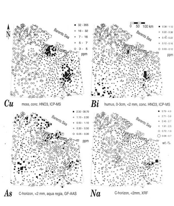
Figure 2: Maps of element distributions (Cu, Bi, As, Na) in the Kola peninsula.
1.) Terrestrial moss (Hylocomium splendens or Pleurozium schreberi) representing primarily element input from the atmosphere;
2.) Humus (up to max. 3 cm thickness) representing the interplay between atmosphere, biosphere and pedosphere;
3.) Topsoil (0-5cm) (mainly for analysis of radionuclides);
4.) Reindeer lichen (Cladina spp. - selected places, for analysis of radionuclides - not included in the atlas);
5.) Complete Podzol profiles (5 horizons - only B- and C-horizon results included in the atlas), representing the geosphere;
6.) Lakewater (Russian project area only), representing the hydrosphere (not included in the atlas).
The atlas presents regional distribution maps for more than 50 elements (228Ac, Ag, Al, 241Am, As, Au, B, Ba, Be, Bi, 218Bi, Br, C, Ca, Cd, Co, Cr, 134Cs, 137Cs, total Cs, Cu, Eu, Fe, H, Hf, Hg, K, 40K, La, Lu, Mg, Mn, Mo, N, Na, Nd, Ni, P, Pb, Rb, S, Sb, Sc, Se, Si, Sm, Sn, Sr, Ta, Tb, Th, Tl, U, V, W, Y, Yb and Zn), pH and LoI. All the samples were always analysed for a defined set of elements/parameters in only one laboratory.
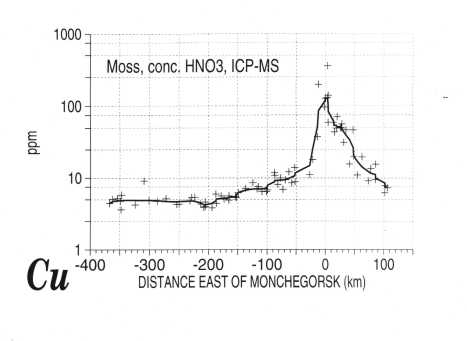
Figure 3: Copper concentration profile from the western border of the survey area eastwards through Monchegorsk.
All three project phases were funded by the Royal Norwegian Ministry of the Environment and the three participating organisations.
In a first follow-up project led by Prof. E.F. Stumpfl, Mining University Leoben and funded by the Austrian Research Council, the mineralogy of snow and humus samples from the immediate vicinity of Nikel, Zapoljarnij and Monchegorsk is presently being investigated using the classical methods of economic geologists (ore microscopy, electron microprobe analysis, geochemistry) (Gregurek et al., 1997).
Regional distribution of elements in different sample media
In terms of exploration geochemistry the Kola ecogeochemistry project is rather unusual: a very low sample density (on average 1 site per 300 km2) is combined with a multitude of different sample media, analysed for very many elements using state of the art analytical techniques to obtain the lowest possible detection limits. Regional geochemical maps have been drawn for more than 50 elements to show their distribution in four main media, moss, uppermost humus (0-3 cm beneath the surface), and the B- and C-horizons in podzol profiles. Whereas the moss maps largely reflect atmospheric input of elements (emissions from industry, sea spray and dust from local geogenic sources), the chemical elements in the upper humus layer reflect a more complex interplay between atmospheric input, sea spray, local geogenic background fluctuations and the biological cycle. The samples from the B- and C-horizons tend to reflect regional geology, thus revealing variations in the natural background levels of the elements. Only where the organic layer of the soil is destroyed, close to the most polluted industrial sites in Russia, is the chemistry of the deeper soil horizons affected by anthropogenic contamination. During the course of the project more than 30 elements were identified as part of the emissions from the Russian nickel industry.
The copper map (Fig. 2) reflects the degree to which contamination from the nickel-copper industry has a regional impact on the chemical composition of the moss. Elevated concentrations can be observed over more than half of the survey area. When studying such a map it is, however, important to look not only at the pattern displayed, but also at the contrast. When looking at an east west profile from the western border of the survey area eastwards through Monchegorsk (Fig. 3) it becomes obvious that element concentrations decrease exponentially from the source towards the background areas. With regard to the ongoing debate concerning long range atmospheric transport of pollutants across national boundaries for hundreds or thousands of km, one of the major surprises of this study is that most elements do not seem to travel very far.
At 100 to at most 200 km (depending on the main wind directions) from the source, it becomes very difficult, if not impossible to separate "pollution" from the natural background fluctuations. Each element shows its own characteristic dispersal function. Simple mass balance calculations for Monchegorsk, based on these results and the official emission figures show that practically the complete mass of heavy metals emitted is needed to create the observed patterns (Caritat et al., 1997b). These observations are backed by recent investigations near Flin Flon in Canada, where a similar regional investigation has shown that a very high percentage of the total metals emitted since start up of the operation in 1930 is still bound in the humus layer in the near surroundings (<100 km) of the smelter (Bonham-Carter and McMartin, 1997).
It is important that geochemists get involved in these very practical research topics. Today much of this research is left to biologists, chemists and meteorologists, who have limited experience about to geoscience and the natural levels and fluctuations of element concentrations with changing bedrock (and local dust...) composition. For many of these authors any measured heavy metal concentration in nature is "man-made pollution". Inventories are published (e.g., Pacyna, 1995) in which the amount of certain metals stated as emitted by the smelting industry on Kola is larger than the actual content of this element in the ore entering the process. Enormous differences in opinion about fluxes of elements and their respective sources are documented in current literature (see Rasmussen, 1996). In the long run, the metals industry will be damaged severely by misconceptions and wrong budgets of biogeochemical cycles if not corrected. There is no doubt that metal mining and smelting has a negative impact on the environment which should be kept at a minimum. At the same time, industry should not be asked that clean up after closure results in lower metal concentrations in the environment than those that are natural for the area, and should not be blamed for any observed environmental degradation just because there is no better explanation at hand. Large scale, regional geochemical maps, documenting element levels and their variation in space at a given time are urgently needed for this purpose. Thus, unbiased inventories, based on sound knowledge of natural element levels and fluctuations, should be produced on a world wide scale (Darnley et al., 1995) to promote the generation of a fair legal framework in which industry can continue to operate.
Another interesting example why geochemists should be involved in environmental work is exemplified by the regional distribution of Bi in humus. The map (Fig. 2) shows rather small anomalies surrounding industry at Nikel and Monchegorsk. The most prominent feature is a steady increase of the Bi-concentrations from north to south, with the highest values reached at the southern boundary of the project area in Finland. Such patterns are interpreted as "typical for long range transported air pollutants" in today’s environmental literature (e.g., Steinnes et al., 1992, Berg et al., 1995) and thus the metals industry is blamed for polluting the environment on a world wide scale. Sources would have to be located somewhere in central Europe. Are there, however, other possible explanations for the pattern observed? A first question to the critical reader is, of course, why the anomalies surrounding Nikel and Monchegorsk, which are both rather prominent Bi-emitters on a European scale, are so limited in size, while rather undefined "central European sources" should be able to cause such a major feature as the south - north gradient in the map. The next question could be why all the long travelled Bi (most possible sources are more than 2000 km away) precipitates on the last 250 km before it reaches the coast of the Barents Sea, where such a pattern would be no longer detectable? There are actually several possible alternative explanations that have nothing to do with industry: from north to south, three important vegetation zones are crossed in the survey area (sub-arctic tundra, sub-arctic birch forest, boreal forest). Already in 1937 Goldschmidt described the influence of vegetation on high levels observed for a multitude of elements in humus without any apparent explanation. Plant species and biomass production can have a major influence on element concentrations observed in humus. Other possible explanations include the ever increasing population and traffic density from north to south. Interestingly, some other elements, for example Rb, for which nobody would assume an anthropogenic origin, show a similar north - south concentration gradient as Bi (and Tl), highlighting the importance of truly multi-element geochemical studies to guide the understanding of the obtained patterns.
More interesting to the explorationist is the very large regional scale of geochemical signatures related to mineralising events visible in many maps. The maps for As and Na (Fig. 2) in the C-horizon show just two examples. The highest As concentrations (note that these are concentrations in the < 2mm fraction) occur over parts of a greenstone belt in the Finnish part of the project area, which is a "hot spot" for gold exploration in Finland. The same area is clearly marked as an anomaly for a multitude of elements even at this low sampling density. The Na map can be taken as an indication that the emplacement of the alkaline intrusions of Khibiny and Lovozero had a major influence on the regional distribution of Na in the C-horizon soils. Many other interesting patterns are visible in the B- and C-horizon maps, some giving arguments for a different interpretation of geological boundaries from those shown in today’s maps, others indicating a high exploration potential for certain sub-areas and different commodities. Today’s exploration geochemists are very much trained to think on the "property" or, maybe "geological unit" scale and in terms of very high sampling densities. The Kola Project is a very good example, showing that low density multi-medium, multi-element geochemistry of very large areas may have an important potential as a powerful tool in mineral exploration.
Formation of a secondary ore deposit?
Topsoil (0-5 cm) in a catchment 5 km from Monchegorsk recorded some exceptionally high concentrations of heavy and noble metals. Copper was as high as 6440 ppm, nickel was up to 6360 ppm, gold 100 ppb, palladium 1.7 ppm (!), and platinum 466 ppb (Boyd et al., 1997). In other words, the soil near Monchegorsk contains concentrations of elements approaching ore grade and may be an interesting resource rather than a pollution problem in the future. Ore geologists could thus study the formation of a secondary ore deposit on land here, almost certainly detect interesting, new mineral phases in soils and might even learn something about the low temperature geochemistry of the noble metals. In terms of value of the yearly emissions from the smelters, the observation of high concentrations of noble metals indicates that above-mentioned US$ 20 million are probably a very conservative estimate.
Radioisotopes
An important aspect of the project was to identify the level of radionuclides in the soils throughout the area studied. For this purpose, large composite samples of the uppermost 5 cm of the soil were collected at each site. The samples were analysed at the Norwegian Radiation Protection Authority for artificial and naturally occurring radionuclides, using gamma spectrometry. The values proved to be very low and can be ascribed to precipitation from atmospheric testing of nuclear bombs in the 1950’s and 1960’s. An interesting pattern was observed for the naturally occurring radioisotope 228Ac, which has a half life of only 6.1 hours, but is in equilibrium with 232Th. A large, regional scale anomaly of 228Ac occurs on top of the granulite belt running from Norway through Finland into Russia (Fig. 4).
Ecosystem damage
The vegetation is completely destroyed over several hundred square kilometres in the surroundings of the smelters, creating "moonscapes" or, in the terminology of our Russian colleagues, "technogenic deserts". They can be easily detected in satellite images and satellite imagery was used to reveal the development of vegetation damage over time (e.g., Tømmervik et al., 1995). A very surprising result of the project was that beginning soil erosion was a more widespread problem in the Finnish and especially Norwegian project areas, far from industry, than in Russia. In these areas, it was not heavy metal contamination or SO2 that was causing the damage, but overgrazing by reindeer. The damage is most widespread on the Norwegian side of the border where 71% of all sites visited showed serious ecosystem damage compared with only 7% in Russia (Kashulina et al., 1997). Thus, an ecosystem whose lichen and mosses contain rather high heavy metal contents, but where no reindeer grazing takes place, can appear substantially healthier than similar grazed areas in Norway with 10 times less metal in lichens, mosses and soil. Reindeer herding, which has been a "natural" part of the way of living of the native population for centuries, has been turned into an industry with much larger herds in the last 30 years.
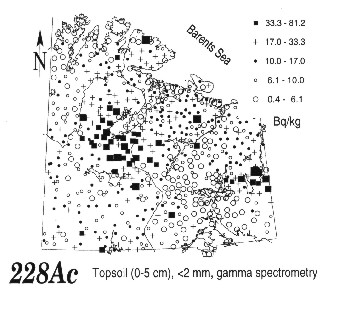
Figure 4: Radioactivity values induced by 228Ac in the Kola peninsula.
Recent investigations into the health situation of the local population failed to show an impact of the metal smelters on levels of nickel in blood and urine, car traffic being an apparently more important source (Smith-Sivertsen, 1997a, b).
Conclusions
The data presented in the environmental geochemical atlas of the central Barents Region can be used to identify and document human impact in the area, as well as the natural levels of the elements. The results show that parts of the area are extremely polluted with a large number of different elements. The data could give a good basis for selecting monitoring sites and will be important for planning investigations of the biological impact of severe heavy metal contamination on the environment. They provide fundamental information on element levels and variations in several media, in both a severely polluted environment and in one of the most pristine areas that can be found in Europe. They show that metal concentrations in all media decrease very abruptly (exponentially) with distance from industry. The amount of metals available for long range atmospheric transport is thus quite limited. They show that more factors than just industry (e.g., vegetation) can have an important influence on metal values observed in other sample media. The environmental impact of the smelters is rather limited in area when compared to other "mobile" human activities using much larger areas. The difference is, that these activities, e.g., reindeer herding (or cars) look rather nice when compared to a metal smelter and the environmental impact is not as obvious to the untrained eye. Public awareness is focused on industry due to the very apparent damage in the immediate surrounding of the smelters or the appearance of many industrial sites in general. Industry might be well advised to put some money into "appearances" - or, as an old German saying goes: "Kleider machen Leute".
For more information see "The Kola Ecogeochemistry Project" on internet: http://www.ngu.no/Kola
REFERENCES
Äyräs, M., de Caritat, P. de, Chekushin, V.A., Niskavaara, H. & Reimann, C., 1995. Ecogeochemical investigation, Kola Peninsula: sulphur and trace element content in snow. Water, Air and Soil Poll., 85: 749-754.
Äyräs, M., Pavlov, V. & Reimann, C., 1997a. Comparison of sulphur and heavy metal contents and their regional distribution in humus and moss samples from the vicinity of Nikel and Zapoljarnij, Kola Peninsula, Russia. Water, Air and Soil Poll., 98: 361-380.
Äyräs, M., Niskavaara, H., Bogatyrev, I., Chekushin, V., Pavlov, V., de Caritat, P. de, Halleraker, J.H., Finne, T.E., Kashulina, G. & Reimann, C., 1997b. Regional atmospheric deposition patterns of heavy metals (Co, Cr, Cu, Fe, Ni, Pb, V and Zn) and sulphur as seen in terrestrial moss samples from a 188,000 km2-area in northern Finland, Norway and Russia. J. Geochem. Explor., 58: 269-281.
Berg, T., Røyset, O., Steinnes, E. and Vadset, M., 1995. Atmospheric trace element deposition: principal component analysis of ICP-MS data from moss samples. Environ. Poll. 88, 1,: 65-77.
Bonham-Carter, G.F. and McMartin, I., 1997. Calculations on metals in humus around the base-metal smelter at Flin Flon, Manitoba, Canada. Pawlowsky-Glahn, V. (ed.): Proceedings of IAMG’97. The third annual conference of the International Association for Mathematical Geology. CIMNE, Barcelona, Spain: 262-267.
Boyd, R., Niskavaara, H., Kontas, E., Chekushin, V., Pavlov, V., Often, M. & Reimann, C., 1997. Anthropogenic noble-metal enrichment of topsoil in the Monchegorsk area, Kola Peninsula, northwest Russia. J. Geochem. Explor., 58: 283-289.
Caritat, P. de, Reimann, C., Äyräs, M., Niskavaara, H., Chekushin, V.A. & Pavlov, V.A., 1996a. Stream water geochemistry from selected catchments on the Kola Peninsula (NW Russia) and in neighbouring areas of Finland and Norway: 1. Element levels and sources. Aquatic Geochemistry, 2: 149-168.
Caritat, P. de, Reimann, C., Äyräs, M., Niskavaara, H., Chekushin, V.A. & Pavlov, V.A., 1996b. Stream water geochemistry from selected catchments on the Kola Peninsula (NW Russia) and in neighbouring areas of Finland and Norway: 2. Time-series. Aquat. Geochemistry, 2: 169-184.
Caritat, P. de, Krouse, H.R. & Hutcheon, I., 1997a. Sulphur isotope composition of stream water, moss and humus from eight Arctic catchments in the Kola Peninsula region (NW Russia, N Finland, NE Norway. Water, Air and Soil Poll., 94: 191-208.
Caritat, P. de, Reimann, C., Chekushin, V.A., Bogatyrev, I.V., Niskavaara, H. & Braun, J., 1997b. Mass balance between emission and deposition of trace metals and sulphur. Environmental Science & Technology, 31: 2966-2972.
Darnley, A.G., Björklund, A., Bølviken, B., Gustavsson, N., Koval, P.V., Plant, J.A., Steenfelt, A., Tauchid, M. and Xuejing, X., 1995. A global geochemical database for environmental and resource management.- Final report of IGCP Project 259.- UNESCO Pub., Earth Sciences 19, 122p.
Goldschmidt V.M., 1937. The principles of distribution of chemical elements in minerals and rocks. Jour. Chem. Soc., London: 655-673.
Gregurek, D., Melcher, F., Stumpfl, E.F., Chekushin, V.A., Niskavaara, H. & Reimann, C., 1997. Environmental pollution linked to nickel ore processing, Kola Peninsula, Russia: The mineralogical and chemical composition of filter residues from snow samples. In: Mineral Deposits (H. Papunen, Ed.), Balkema, Rotterdam: 903-906.
Kashulina, G., Reimann, C., Finne, T.E., Halleraker, J.H., Äyräs, M. & Chekushin, V.A., 1997. The state of the ecosystems in the Central Barents Region: scale, factors and mechanism of disturbance. The Science of the Total Environment, 206: 203-225.
MRCENR, Murmansk Regional Committee for Ecology and Natural Resources, 1995: Review of pollutant fallout in the atmosphere in the Murmansk region in 1993 and 1994, Murmansk, 1995 (in Russian).
Niskavaara, H., Reimann, C. & Chekushin, V., 1996. Distribution and pathways of heavy metals and sulphur in the vicinity of the copper-nickel smelters in Nikel and Zapoljarnij, Kola Peninsula, Russia, as revealed by different sample media. Applied Geochemistry, 11: 25-34.
Niskavaara, H., Reimann, C., Chekushin, V.A. & Kashulina, G., 1997. Seasonal variability of total and easily leachable element contents in topsoils (0-5 cm) from eight catchments in the European Arctic (Finland, Norway and Russia). Environmental Pollution, 96: 261-274.
Pacyna, J.M., 1995. The origin of arctic air pollutants: lessons learned and future research. The Science of the Total Environment, 160/161: 39-53.
Rasmussen, P.E. (1996): Trace metals in the environment: a geological perspective. Geological Survey of Canada Bulletin 429, Geological Survey of Canada, Ottawa, Canada, 26 p.
Reimann, C., Niskavaara, H., Finne, T.E., Äyräs, M. & Chekushin, V., 1996. Regional variation of snowpack chemistry from the surrounding of Nikel and Zapoljarnij, Russia, northern Finland and Norway. The Science of the Total Environment, 182/1-3: 147-158.
Reimann, C., Boyd, R., Caritat, P. de, Halleraker, J.H., Kashulina, G., Niskavaara, H. & Bogatyrev, I., 1997a. Topsoil (0-5 cm) composition in eight arctic catchments in northern Europe (Finland, Norway and Russia). Environmental Pollution, 95: 45-56.
Reimann, C., Caritat, P. de, Halleraker, J.H., Volden, T., Äyräs, M., Niskavaara, H., Chekushin, V.A. & Pavlov, V.A., 1997b. Rainwater composition in eight arctic catchments of northern Europe (Finland, Norway and Russia). Atmospheric Environment, 31/1: 159-170.
Reimann, C., Caritat, P. de., Halleraker, J.H., Finne, T.E., Boyd, R., Jæger, Ø., Volden, T., Kashulina, G., Bogatyrev, I., Chekushin, V., Pavlov, V., Äyräs, M., Räisänen, M.L. & Niskavaara, H., 1997c. Regional atmospheric deposition patterns of Ag, As, Bi, Cd, Hg, Mo, Sb and Tl in a 188,000 km2 area in the European Arctic as displayed by terrestrial moss samples - long range atmospheric transport versus local impact. Atmospheric Environment, 31/23: 3887-3901.
Smith-Sivertsen, T., Lund, E., Thomassen, Y. and Norseth, T., 1997a. Human exposure in an area polluted by nickel refining. The Sør-Varanger study. Archives of Environmental Health, 52 (6): 464-471.
Smith-Sivertsen, T., Tchachtchine, V. Lund, E. Norseth, T. & Bykov, V., 1997b. The Norwegian - Russian health study 1994/95. A cross-sectional study of pollution and health in the border area. ISM skrifteserie, Institutt for samfunnsmedisin, Tromsø, 42, 56 pp. + figures, tables, appendix.
Steinnes, E., Rambæk, J.P. and Hanssen, J.E., 1992. Large scale multi-element survey of atmospheric deposition using naturally growing moss as biomonitor. Chemosphere, 25, 5: 735-752.
Tømmervik H., Johansen B. E. & Pedersen J. P. 1995. Monitoring the effects of air pollution on terrestrial ecosystems in Varanger (Norway) and Nikel-Pechenga (Russia) using remote sensing. The Science of the Total Environment, 160-161: 753-767.